2019- 2023 Powdermill Lane: Georgian and Victorian Corn Mill
The Powder Mill Lane site forms part of a larger industrial setting in Southborough Valley, with forges, gunpowder works and mills active since the Tudor period through to the 20th Century. Water and associated water management has been a driving and critical part of the development (and demise) of industry within the valley.
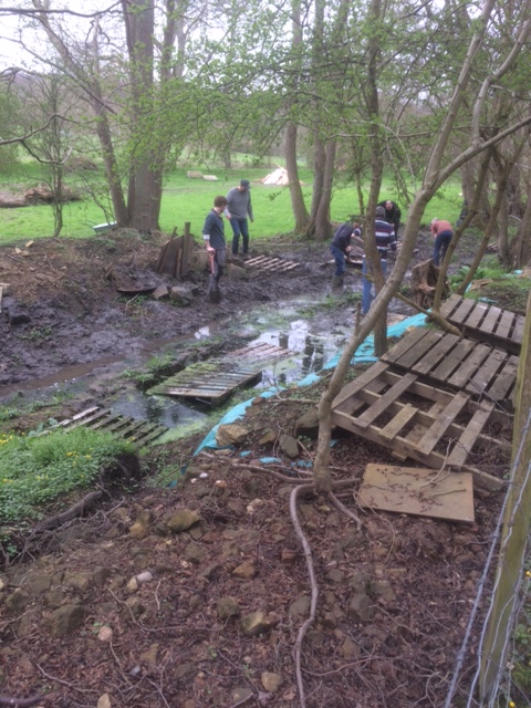
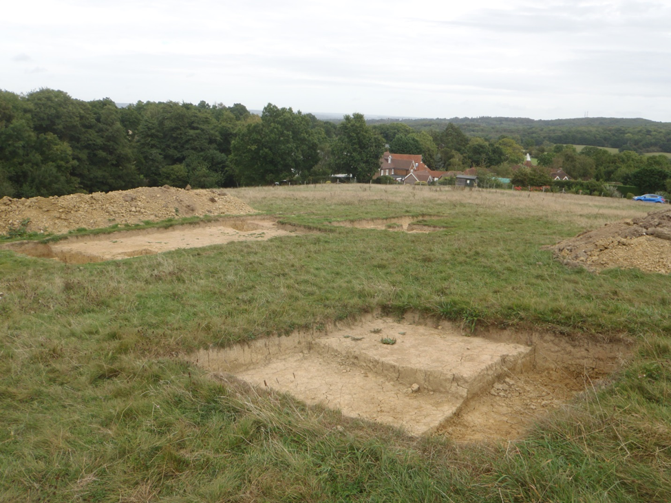
The excavation started in 2019 and continued to 2023 (with a break for Covid-19 in 2020) revealing an "L" shaped building with a waterwheel, which was extended in the 1880s. Having identified Mill walls
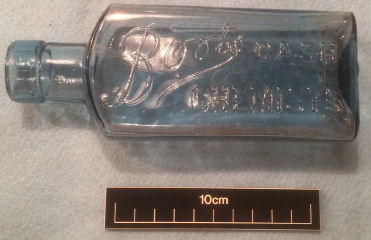
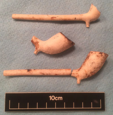
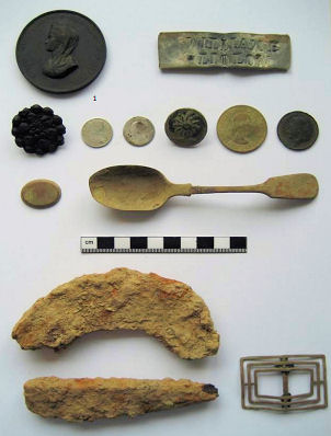
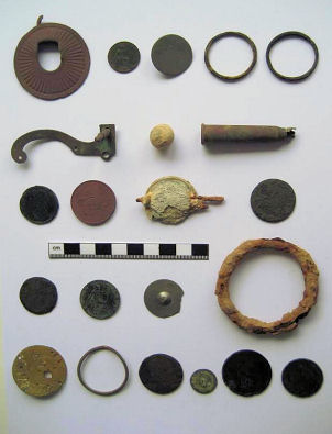
(at foundation level) we identified numerous brick structures, including brick pillars to support the waterwheel. Over 500 finds have been discovered which include a range of industrial and domestic objects, such as clay pipe stems, glazed pottery and industrial iron implements.
Tithe Map of 1840 -
Site appears as two small buildings above "2566"
1898 OS Map (courtesy of National Museum of Scotland).
Site is now established as a Corn Mill
The 1840 Tithe map shows two small buildings on our Powder Mill Lane site (probably gunpowder works) which were replaced by a later corn mill in 1845, whose development can be traced through map evidence prior to its demolition in 1938.
This site was excavated based on the visual identification of brick walls matching the location of two buildings which are visible on the 1840 Tithe map, and a later larger building (Corn Mill) which evolved on the site during the Victorian and Edwardian period. An addition of a large waterwheel was to provide power for the grinding of the corn. The earlier buildings may have been used for gunpowder production, but until relevant gunpowder milling artefacts are found this cannot be proven.
Brick structures linked with the mill site have been found, plus a range of domestic and industrial finds many of which have been added to the site at a later date. Water management and control of mill ponds, sluice gates and the waterwheel are key to understanding the function of the site, which will hopefully be explored further in 2020 (or in 2021). The water management developed through time, reflecting different industrial requirements and fluctuating water supplies, with buildings probably occupying several sites in the valley and their locations captured through the map and field evidence.
SHAAS Research Team
SHAAS has an active research team providing essential background information to help guide the excavations to ensure maximum productivity. As an example of the team's work, they have uncovered the following history of our Powder Mill Lane sites:
The Southborough Valley used to be part of the South Frith estate and at that time there were Tudor iron workings, streams, forests and a deer park. Our site is shown on an early 17th Century map of Kent.
In 1553 David Willard built a forge for Sir Thomas Fane on our Powder Mill site. We call it Old Forge and we think it was originally built on the mill pond bay, now underneath a large modern barn. The forge worked in conjunction with Vauxhall Furnace from 1623-79 and refined smelted iron sent down river from the Furnace.
In 1763, the Forge was converted to a Pestle Forge, though we assume that iron working became unprofitable, as in 1771 or 1772, at Old Forge Farm, a gunpowder mill was set up by a carpenter who had worked at Powder Mills at Battle'.
A corn mill replaced the powder mill in 1845 and may have been working as late as 1923, before being sold for scrap in 1932. The forge and mill locations changed through time with the new buildings either updating existing structures or being built specifically to meet their new functions.
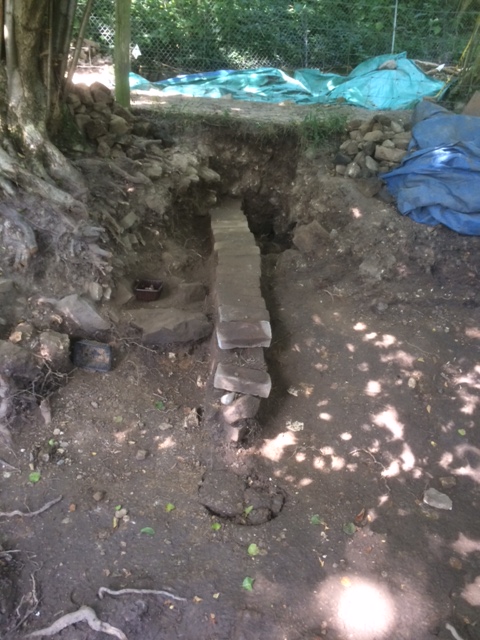
The Powder Mill Lane site was excavated based on the discovery of a brick wall as part of a revetment which forms part of the northern edge of an old mill pond. The 1840 Tithe map shows a building on our site which was demolished as part of the construction of the Colebrook railway viaduct & associated embankment in 1845. The brick wall in the revetment was probably associated with a waterwheel, indicating industrial use, with power being supplied by the waterwheel which could have been used to drive equipment such as trip hammers. This might also have been the location of an earlier gunpowder mill, as forges and gunpowder works dominated the early industrial landscape of the Southborough valley.
A diverse range finds have been located, including a mixture of domestic items, such as clay pipe stems and glazed pottery; industrial items, such as metal tools and railway related equipment; plus a possible fragment of a waterwheel paddle. Findings of slag across the site indicate the presence of metal working forges, including a finery forge, in the vicinity of the site.
Download 2017-18 Powdermill Forge Building Interim Report. Please click on the pdf icon:
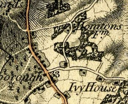
2016 Honnington Farm - Medieval Fruit Processing Facility
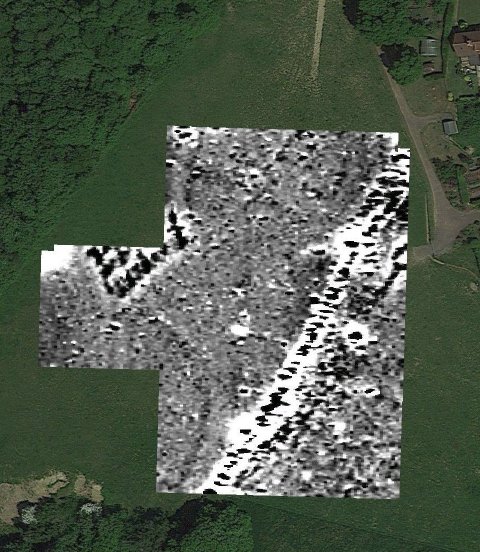
The Honnington Farm site (Vauxhall Lane) was excavated based on the findings of a geophysical survey, which indicated a rectangular magnetic anomaly (30m x 20m) located parallel to the edge of an old orchard and next to a track way leading from Southborough to Tonbridge The outcome of the excavation was that the rectangular magnetic anomaly matched the position of a late 19th Century deposit of CBM (Ceramic Building Materials) which contained magnetised material. Based on the location and age of the site, one possible scenario was that the site represented a wooden barn, located at the edge of the orchard and next to a track way, where produce was collected, packaged and sent to Tonbridge for shipment to London via the then newly established railway.
Download Honnington Metal Detecting Report. Please click on the pdf icon:
Download Honnington Excavation Report. Please click on the pdf icon:
This was the first site explored by SHAAS and is located deep among the trees in Brokes Wood. The site includes a primary bloomery furnace dating to the Middle Iron Age c.500BC, plus associated evidence of buildings (via post holes) and secondary (smaller) furnaces. Locally produced charcoal and nearby ironstone would have provided the raw materials to support this industry, which developed as a major iron producer in the Weald area through the Iron Age and Roman period, and later in the 15th to 18th centuries when it dominated production of bar iron (16th century) and later British cannon production (until c. 1770), before declining due to technology changes (eg use of coke) and foreign competition.
Download Brokes Wood Archaeological Assessment. Please click on the pdf icon:...